
ගොනුව:Sri Lanka geopolitics - after "Spoiling of Vijayabahu".png

මුල් ගොනුව (2,441 × 3,257 පික්සල, ගොනු විශාලත්වය: 575 කි.බ., MIME ශෛලිය: image/png)
සාරාංශය
| විස්තරය |
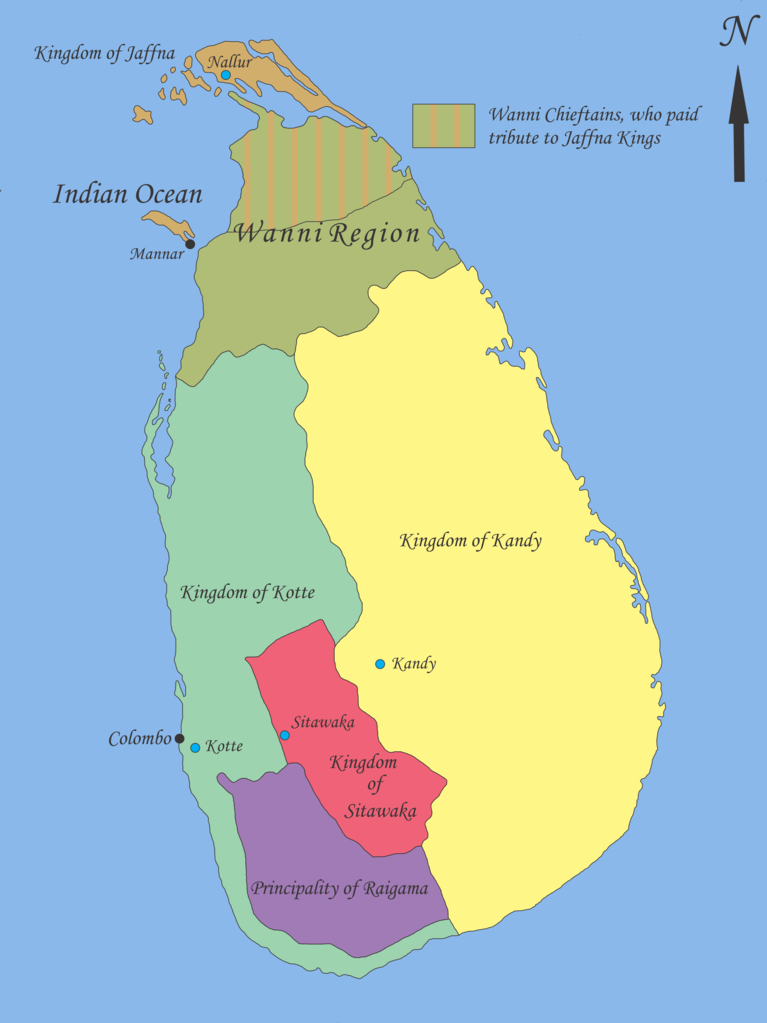
English: Map showing geopolitical situation in Sri Lanka in the early part of 16th century after the “Spoiling of Vijayabahu” in 1521. Map based on following sources;
- “Year 8 History Text Book – Government Publication”, THE ARRIVAL OF THE PORTUGUESE IN SRI LANKA: p14, 06th September 2012. -Fernao de Queyroz. The temporal and spiritual conquest of Ceylon. AES reprint. New Delhi: Asian Educational Services; 1995. p 47-58 ISBN 81-206-0765-1 -Captain Joao Ribeiro. The historic Tragedy of the island of Ceilao. AES Reprint. New Delhi: Asian Educational Services; 1999. p5 ISBN 81-206-1334-1 -Phillipus Baldaeus. A True and Exact Description of the Great Island of Ceylon. English Translation by Pieter Brohier. The Ceylon Historical Journal – Published in Co-operation with the Ceylon Branch of Royal Asiatic Society. Volume III, No 1-4; July 1958 to April 1959. p 300-301 Following maps were used to identify limitations of areas and not for the map itself. -DE L'ISLE:G. - Carte de l'Isle de Ceylan. Published in Paris 1723. http://www.swaen.com/antique-map-of.php?id=1777 , 06 September 2012 - VALENTIJN,F. - Nieuwe Kaart van het Eyland Ceylon opgestelt door. Published in Amsterdam 1724 http://www.swaen.com/antique-map-of.php?id=736 |
| දිනය | |
| මූලාශ්රය | ස්වයං නිර්මාණයකි |
| කර්තෘ | Nishadhi |
බලපත්රීකරණය
- ඔබ නිදහස්:
- බෙදාහදා ගැනීමට – කාර්යය පිටපත් කිරීමට,බෙදා හැරීමට සහ සම්ප්රේෂණය කිරීමට
- නැවත සංකලනය කිරීමට – කාර්යයට අනුවර්තනය වීමට
- පහත කොන්දේසිවලට යටත්ව:
- attribution – වරපත වෙත බැඳියක්ද සපයමින් ඔබ විසින් සුදුසු කර්තෘභාරය ප්රදානය කල යුතු අතර, කිසියම් වෙනස්වීම් සිදුකලේ නම් එයද සඳහන් කල යුතු වෙයි. ඕනෑම සුදුසු ආකාරයට මෙය ඔබ විසින් සිදුකල හැකි මුත්, වරපත්දායකයා විසින් ඔබ හෝ ඔබගේ භාවිතය හෝ පිටසන් කරන බවට ඇඟවෙන ලෙසින් එය සිදු නොකල යුතු වෙයි.
- share alike – මෙම විෂය කාරණා භාවිතා කොට නැවත සංකලනය, ප්රතියෝජනය හෝ වැඩිදියුණුව කලේ නම්, ඉන්පසු ඔබගේ දායකත්වය ඔබ විසින් බෙදාහැරිය යුත්තේ මුල් වරපත හා සමාන හෝ සංගතික හෝ වරපතක් භාවිතා කරමිනි.

|
Free Software Foundation විසින් ප්රකාශිත GNU Free Documentation License බලපත්රයෙහි 1.2 හෝ ඊට අලුත් පිටපත්වල කොන්දේසිවලට යටත්ව මෙම ගොනුව පිටපත් කෙරුමට, නැවත බෙදාහාරුමට සහ/හෝ වෙනස් කෙරුමට අවසර දී ඇත; ඒ වෙනස් අංශ නොමැතිව, මුල් පිටු පෙළ නොමැතිව, පසු පිටු පෙළ නොමැතිවය. බලපත්රයේ පිටපතක් GNU Free Documentation License නම් අංශයේ දැක්වේ. |
ප්රකෘති පැටවුම් ලොගය
- 2012-09-21 18:02 Nishadhi 2441×3257× (589067 bytes) Spelling mistake corrected.
- 2012-09-16 15:48 Nishadhi 2441×3257× (589023 bytes) Map showing geopolitical situation in Sri Lanka in the early part of 16th century after the “Spoiling of Vijayabahu” in 1521. Map based on following sources; - “Year 8 History Text Book – Government Publication”, THE ARRIVAL OF THE PORTUGUESE...
ගොනු ඉතිහාසය
එම අවස්ථාවෙහිදී ගොනුව පැවැති ආකාරය නැරඹීමට දිනය/වේලාව මත ක්ලික් කරන්න.
| දිනය/වේලාව | කුඩා-රූපය | මාන | පරිශීලක | පරිකථනය | |
|---|---|---|---|---|---|
| වත්මන් | 19:04, 25 දෙසැම්බර් 2014 | | 2,441 × 3,257 (575 කි.බ.) | OgreBot | (BOT): Reverting to most recent version before archival |
| 19:04, 25 දෙසැම්බර් 2014 |  | 2,441 × 3,257 (575 කි.බ.) | OgreBot | (BOT): Uploading old version of file from en.wikipedia; originally uploaded on 2012-09-16 15:48:39 by Nishadhi | |
| 18:25, 21 සැප්තැම්බර් 2012 |  | 2,441 × 3,257 (575 කි.බ.) | Nishadhi | {{Information |Description ={{en|1=Map showing geopolitical situation in Sri Lanka in the early part of 16th century after the “Spoiling of Vijayabahu” in 1521. Map based on following sources; - “Year 8 History Text Book – Government Public... |
ගොනු භාවිතය
පහත දැක්වෙන පිටු 2 ක් විසින් මෙම ගොනුව භාවිතා කෙරෙයි:
ගෝලීය ගොනු භාවිතය
පහත දැක්වෙන අනෙකුත් විකියන් මගින් මෙම ගොනුව භාවිතා කරයි:
- ca.wikipedia.org හි භාවිතය
- de.wikipedia.org හි භාවිතය
- en.wikipedia.org හි භාවිතය
- Bayinnaung
- Kingdom of Kandy
- Vanni chieftaincies
- Vijayabā Kollaya
- Kingdom of Kotte
- User:Blackknight12/sandbox
- User:Nishadhi
- Siege of Kotte (1557–1558)
- Campaign of Danture
- Siege of Galle (1640)
- Sinhalese–Portuguese conflicts
- Sinhalese monarchy
- Transitional period of Sri Lanka
- User:Tisquesusa/sandbox9
- User:Blackknight12/sandbox2
- Myanmar–Sri Lanka relations
- fi.wikipedia.org හි භාවිතය
- fr.wikipedia.org හි භාවිතය
- it.wikipedia.org හි භාවිතය
- ka.wikipedia.org හි භාවිතය
- ko.wikipedia.org හි භාවිතය
- my.wikipedia.org හි භාවිතය
- nl.wikipedia.org හි භාවිතය
- pl.wikipedia.org හි භාවිතය
- pt.wikipedia.org හි භාවිතය
- sl.wikipedia.org හි භාවිතය
- ta.wikipedia.org හි භාවිතය
- ur.wikipedia.org හි භාවිතය
- zh.wikipedia.org හි භාවිතය