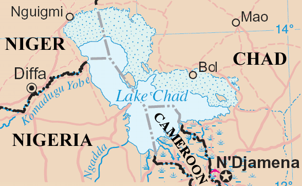
ගොනුව:Lakechad map.png
Lakechad_map.png (588 × 362 පික්සල, ගොනු විශාලත්වය: 38 කි.බ., MIME ශෛලිය: image/png)
ගොනු ඉතිහාසය
එම අවස්ථාවෙහිදී ගොනුව පැවැති ආකාරය නැරඹීමට දිනය/වේලාව මත ක්ලික් කරන්න.
| දිනය/වේලාව | කුඩා-රූපය | මාන | පරිශීලක | පරිකථනය | |
|---|---|---|---|---|---|
| වත්මන් | 16:20, 23 මැයි 2006 |  | 588 × 362 (38 කි.බ.) | Amcaja | Lake Chad and surrounding area Map adapted from http://www.un.org/Depts/Cartographic/map/profile/niger.pdf {{UN map}} Category:Maps Category:Maps of Cameroon |
ගොනු භාවිතය
පහත දැක්වෙන පිටුව විසින් මෙම ගොනුව භාවිතා කෙරෙයි:
ගෝලීය ගොනු භාවිතය
පහත දැක්වෙන අනෙකුත් විකියන් මගින් මෙම ගොනුව භාවිතා කරයි:
- af.wikipedia.org හි භාවිතය
- an.wikipedia.org හි භාවිතය
- ar.wikipedia.org හි භාවිතය
- bn.wikipedia.org හි භාවිතය
- cy.wikipedia.org හි භාවිතය
- el.wikipedia.org හි භාවිතය
- en.wikipedia.org හි භාවිතය
- es.wikipedia.org හි භාවිතය
- fa.wikipedia.org හි භාවිතය
- fi.wikipedia.org හි භාවිතය
- fr.wikipedia.org හි භාවිතය
- fy.wikipedia.org හි භාවිතය
- he.wikipedia.org හි භාවිතය
- hr.wikipedia.org හි භාවිතය
- id.wikipedia.org හි භාවිතය
- incubator.wikimedia.org හි භාවිතය
- io.wikipedia.org හි භාවිතය
- ja.wikipedia.org හි භාවිතය
- ka.wikipedia.org හි භාවිතය
- kcg.wikipedia.org හි භාවිතය
- ko.wikipedia.org හි භාවිතය
- la.wikipedia.org හි භාවිතය
- lb.wikipedia.org හි භාවිතය
- lt.wikipedia.org හි භාවිතය
- mg.wikipedia.org හි භාවිතය
- mn.wikipedia.org හි භාවිතය
- ms.wikipedia.org හි භාවිතය
- mt.wikipedia.org හි භාවිතය
- my.wikipedia.org හි භාවිතය
- nds-nl.wikipedia.org හි භාවිතය
- nl.wikipedia.org හි භාවිතය
- no.wikipedia.org හි භාවිතය
- oc.wikipedia.org හි භාවිතය
- pa.wikipedia.org හි භාවිතය
- pt.wikipedia.org හි භාවිතය
- qu.wikipedia.org හි භාවිතය
- ro.wikipedia.org හි භාවිතය
- sc.wikipedia.org හි භාවිතය
- sh.wikipedia.org හි භාවිතය
- simple.wikipedia.org හි භාවිතය
- sk.wikipedia.org හි භාවිතය
- sl.wikipedia.org හි භාවිතය
මෙම ගොනුවේ තවත් ගෝලීය භාවිත බලන්න.


