
ගොනුව:Germany former prussian lander.png
මෙයට ඉහල විසර්ජනයක් ලබාගත නොහැක.
Germany_former_prussian_lander.png (444 × 599 පික්සල, ගොනු විශාලත්වය: 18 කි.බ., MIME ශෛලිය: image/png)
සාරාංශය
| විස්තරය |
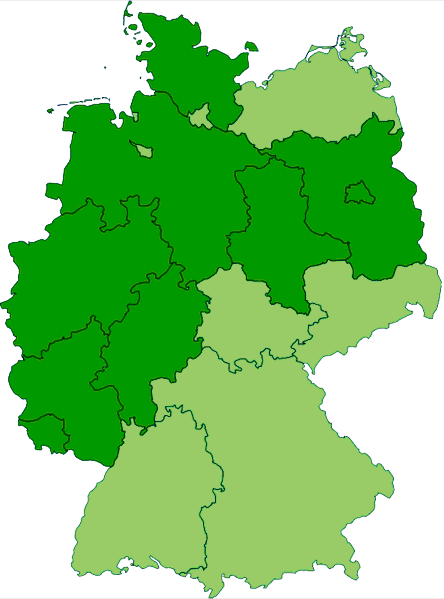
English: Map of current states of Germany that are completely or mostly situated inside the old borders of Imperial Germany's Kingdom of Prussia (in dark green). |
| දිනය | 10 අප්රේල් 2008 (original upload date) |
| මූලාශ්රය | ස්වයං නිර්මාණයකි |
| කර්තෘ | MaGioZal |
බලපත්රීකරණය
MaGioZal, මෙම කාර්යයේ ප්රකාශන අයිතිය දරන්නා,පහත බලපත්රය යටතේ එය ප්රකාශයට පත් කරනු ලබයි:
මෙම ගොනුව Creative Commons Attribution-Share Alike 3.0 Unported, 2.5 Generic, 2.0 Generic සහ 1.0 Generic යටතේ ලියාපදිංචි කර ඇත.
Attribution: MaGioZal
- ඔබ නිදහස්:
- බෙදාහදා ගැනීමට – කාර්යය පිටපත් කිරීමට,බෙදා හැරීමට සහ සම්ප්රේෂණය කිරීමට
- නැවත සංකලනය කිරීමට – කාර්යයට අනුවර්තනය වීමට
- පහත කොන්දේසිවලට යටත්ව:
- attribution – වරපත වෙත බැඳියක්ද සපයමින් ඔබ විසින් සුදුසු කර්තෘභාරය ප්රදානය කල යුතු අතර, කිසියම් වෙනස්වීම් සිදුකලේ නම් එයද සඳහන් කල යුතු වෙයි. ඕනෑම සුදුසු ආකාරයට මෙය ඔබ විසින් සිදුකල හැකි මුත්, වරපත්දායකයා විසින් ඔබ හෝ ඔබගේ භාවිතය හෝ පිටසන් කරන බවට ඇඟවෙන ලෙසින් එය සිදු නොකල යුතු වෙයි.
- share alike – මෙම විෂය කාරණා භාවිතා කොට නැවත සංකලනය, ප්රතියෝජනය හෝ වැඩිදියුණුව කලේ නම්, ඉන්පසු ඔබගේ දායකත්වය ඔබ විසින් බෙදාහැරිය යුත්තේ මුල් වරපත හා සමාන හෝ සංගතික හෝ වරපතක් භාවිතා කරමිනි.

|
Free Software Foundation විසින් ප්රකාශිත GNU Free Documentation License බලපත්රයෙහි 1.2 හෝ ඊට අලුත් පිටපත්වල කොන්දේසිවලට යටත්ව මෙම ගොනුව පිටපත් කෙරුමට, නැවත බෙදාහාරුමට සහ/හෝ වෙනස් කෙරුමට අවසර දී ඇත; ඒ වෙනස් අංශ නොමැතිව, මුල් පිටු පෙළ නොමැතිව, පසු පිටු පෙළ නොමැතිවය. බලපත්රයේ පිටපතක් GNU Free Documentation License නම් අංශයේ දැක්වේ. |
ඔබට අභිමත වරපත තෝරාගත හැක.
ප්රකෘති පැටවුම් ලොගය
Transferred from en.wikipedia to Commons by Frokor using CommonsHelper.
The original description page was here. All following user names refer to en.wikipedia.
- 2008-04-10 20:43 MaGioZal 444×599 (18217 bytes) âMap of current [[states of Germany]] that were completely or mostly situated inside of the borders of [[Imperial Germany]]âs [[Kingdom of Prussia]].
ගොනු ඉතිහාසය
එම අවස්ථාවෙහිදී ගොනුව පැවැති ආකාරය නැරඹීමට දිනය/වේලාව මත ක්ලික් කරන්න.
| දිනය/වේලාව | කුඩා-රූපය | මාන | පරිශීලක | පරිකථනය | |
|---|---|---|---|---|---|
| වත්මන් | 22:59, 4 ජූනි 2008 | | 444 × 599 (18 කි.බ.) | File Upload Bot (Magnus Manske) | {{BotMoveToCommons|en.wikipedia}} {{Information |Description={{en|Map of current en:states of Germany that are completely or mostly situated inside the old borders of en:Imperial Germanyâs en:Kingdom of Prussia (in dark green).}} |Sou |
ගොනු භාවිතය
මෙම ගොනුව භාවිතා කරන නිසිදු පිටුවක් නොමැත.
ගෝලීය ගොනු භාවිතය
පහත දැක්වෙන අනෙකුත් විකියන් මගින් මෙම ගොනුව භාවිතා කරයි:
- ar.wikipedia.org හි භාවිතය
- ca.wikipedia.org හි භාවිතය
- en.wikipedia.org හි භාවිතය
- eo.wikipedia.org හි භාවිතය
- es.wikipedia.org හි භාවිතය
- fi.wikipedia.org හි භාවිතය
- fy.wikipedia.org හි භාවිතය
- he.wikipedia.org හි භාවිතය
- hr.wikipedia.org හි භාවිතය
- it.wikipedia.org හි භාවිතය
- km.wikipedia.org හි භාවිතය
- mk.wikipedia.org හි භාවිතය
- nl.wikipedia.org හි භාවිතය
- nn.wikipedia.org හි භාවිතය
- no.wikipedia.org හි භාවිතය
- pt.wikipedia.org හි භාවිතය
- sh.wikipedia.org හි භාවිතය
- sq.wikipedia.org හි භාවිතය
- sr.wikipedia.org හි භාවිතය
- zh.wikipedia.org හි භාවිතය