
ගොනුව:Circum-Arctic Map of Permafrost and Ground Ice Conditions.png
මෙම පෙරදසුනෙහි විශාලත්වය: 534 × 599 පික්සල. අනෙකුත් විභේදනයන්: 214 × 240 පික්සල | 428 × 480 පික්සල | 683 × 766 පික්සල.
මුල් ගොනුව (683 × 766 පික්සල, ගොනු විශාලත්වය: 29 කි.බ., MIME ශෛලිය: image/png)

|
This map image could be re-created using vector graphics as an SVG file. This has several advantages; see Commons:Media for cleanup for more information. If an SVG form of this image is available, please upload it and afterwards replace this template with
{{vector version available|new image name}}.
It is recommended to name the SVG file “Circum-Arctic Map of Permafrost and Ground Ice Conditions.svg”—then the template Vector version available (or Vva) does not need the new image name parameter. |
සාරාංශය
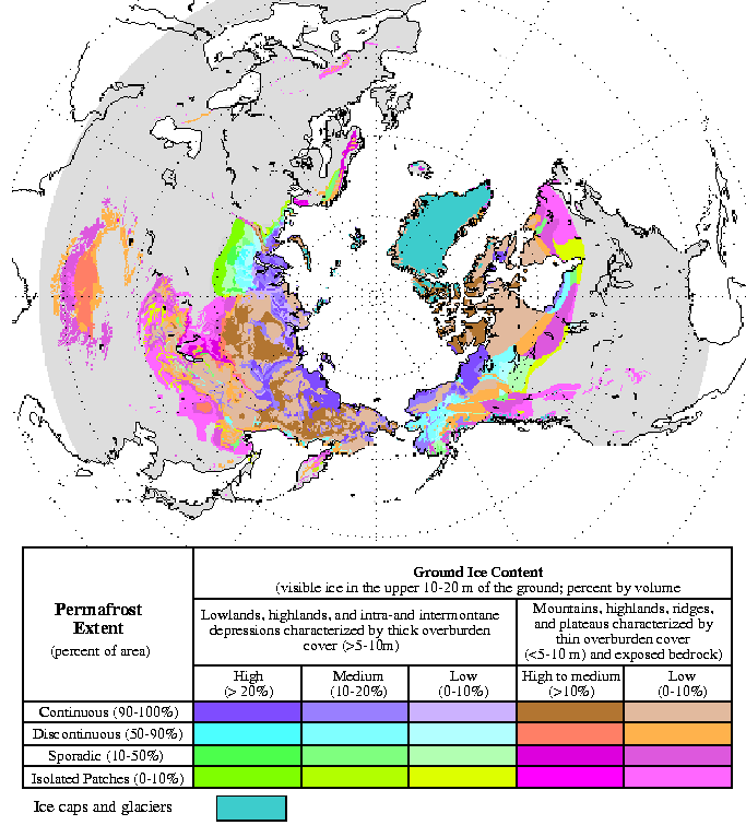
| විස්තරය | Circum-Arctic Map of Permafrost and Ground Ice Conditions |
| දිනය | 1998, revised February 2001 |
| මූලාශ්රය | http://nsidc.org/data/docs/fgdc/ggd318_map_circumarctic/index.html |
| කර්තෘ | Brown, J., O.J. Ferrians, Jr., J.A. Heginbottom, and E.S. Melnikov. 1998, revised February 2001. Circum-arctic map of permafrost and ground ice conditions. Boulder, CO: National Snow and Ice Data Center/World Data Center for Glaciology |
බලපත්රීකරණය
This work is in the public domain in the United States because it is a work prepared by an officer or employee of the United States Government as part of that person’s official duties under the terms of Title 17, Chapter 1, Section 105 of the US Code.
Note: This only applies to original works of the Federal Government and not to the work of any individual U.S. state, territory, commonwealth, county, municipality, or any other subdivision. This template also does not apply to postage stamp designs published by the United States Postal Service since 1978. (See § 313.6(C)(1) of Compendium of U.S. Copyright Office Practices). It also does not apply to certain US coins; see The US Mint Terms of Use.
|
 | |
| මෙම ගොනුව ප්රතිරූපණ හිමිකම් අයිතියෙන්, වෙනත් සියළුම ආශ්රිත හෝ ආසන්න අයිතියන් ඇතුළුව, දන්නා සියළු සීමා කිරීම්වලින් නිදහස් බව හඳුනාගෙන ඇත. | ||
ගොනු ඉතිහාසය
එම අවස්ථාවෙහිදී ගොනුව පැවැති ආකාරය නැරඹීමට දිනය/වේලාව මත ක්ලික් කරන්න.
| දිනය/වේලාව | කුඩා-රූපය | මාන | පරිශීලක | පරිකථනය | |
|---|---|---|---|---|---|
| වත්මන් | 13:21, 23 මාර්තු 2015 | | 683 × 766 (29 කි.බ.) | RokerHRO | optipng -o7 -i0 → 35.32% decrease |
| 18:40, 21 මැයි 2008 |  | 683 × 766 (44 කි.බ.) | Sagredo | {{Information |Description=Circum-Arctic Map of Permafrost and Ground Ice Conditions |Source=http://nsidc.org/data/docs/fgdc/ggd318_map_circumarctic/index.html |Date=1998, revised February 2001 |Author=Brown, J., O.J. Ferrians, Jr., J.A. Heginbottom, and |
ගොනු භාවිතය
පහත දැක්වෙන පිටුව විසින් මෙම ගොනුව භාවිතා කෙරෙයි:
ගෝලීය ගොනු භාවිතය
පහත දැක්වෙන අනෙකුත් විකියන් මගින් මෙම ගොනුව භාවිතා කරයි:
- bxr.wikipedia.org හි භාවිතය
- ca.wikipedia.org හි භාවිතය
- ckb.wikipedia.org හි භාවිතය
- cs.wikipedia.org හි භාවිතය
- de.wikipedia.org හි භාවිතය
- el.wikipedia.org හි භාවිතය
- en.wikipedia.org හි භාවිතය
- eo.wikipedia.org හි භාවිතය
- eu.wikipedia.org හි භාවිතය
- fa.wikipedia.org හි භාවිතය
- fr.wikipedia.org හි භාවිතය
- gl.wikipedia.org හි භාවිතය
- ha.wikipedia.org හි භාවිතය
- he.wikipedia.org හි භාවිතය
- ויקיפדיה:ערכים מומלצים/המלצות קודמות/פברואר 2017
- קפאת-עד
- תבנית:ערך מומלץ 19 בפברואר 2017
- תבנית:ערך מומלץ 20 בפברואר 2017
- פורטל:ערכים מומלצים/ערכים/קפאת-עד
- ויקיפדיה:ערכים מומלצים/המלצות קודמות/אפריל 2022
- ויקיפדיה:ערכים מומלצים/המלצות קודמות/פברואר 2024
- תבנית:ערך מומלץ 4 באפריל 2022
- תבנית:ערך מומלץ 14 בפברואר 2024
- hr.wikipedia.org හි භාවිතය
- id.wikipedia.org හි භාවිතය
- it.wikipedia.org හි භාවිතය
- ko.wikipedia.org හි භාවිතය
- ms.wikipedia.org හි භාවිතය
- ro.wikipedia.org හි භාවිතය
- ru.wikipedia.org හි භාවිතය
- simple.wikipedia.org හි භාවිතය
- sl.wikipedia.org හි භාවිතය
- sv.wikipedia.org හි භාවිතය
- tr.wikipedia.org හි භාවිතය
- uk.wikipedia.org හි භාවිතය
- zh.wikipedia.org හි භාවිතය