
ගොනුව:Acprussiamap2.gif
මෙයට ඉහල විසර්ජනයක් ලබාගත නොහැක.
Acprussiamap2.gif (510 × 357 පික්සල, ගොනු විශාලත්වය: 27 කි.බ., MIME ශෛලිය: image/gif, 0.1තත්)

This image was copied from wikipedia:pt. The original description was:
Licença GNU, fonte en:Wikipedia.

|
Free Software Foundation විසින් ප්රකාශිත GNU Free Documentation License බලපත්රයෙහි 1.2 හෝ ඊට අලුත් පිටපත්වල කොන්දේසිවලට යටත්ව මෙම ගොනුව පිටපත් කෙරුමට, නැවත බෙදාහාරුමට සහ/හෝ වෙනස් කෙරුමට අවසර දී ඇත; ඒ වෙනස් අංශ නොමැතිව, මුල් පිටු පෙළ නොමැතිව, පසු පිටු පෙළ නොමැතිවය. බලපත්රයේ පිටපතක් GNU Free Documentation License නම් අංශයේ දැක්වේ. |
| මෙම ගොනුව ක්රියේටිව් කොමන්ස් Attribution-Share Alike 3.0 Unported වරපත යටතේ අවසර ලබා ඇත. | ||
| ||
| GFDL බලපත්ර යාවත්කාල කෙරුමහි කොටසක් ලෙස මෙම ගොනුවට බලපත්ර ටැගය එක් කෙරිනි. |

|
This map has been uploaded by Electionworld from en.wikipedia.org to enable the |
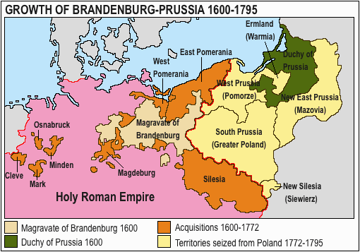
Growth of Prussia en:Image:Ac.prussiamap2.gif

|
This historical map image could be re-created using vector graphics as an SVG file. This has several advantages; see Commons:Media for cleanup for more information. If an SVG form of this image is available, please upload it and afterwards replace this template with
{{vector version available|new image name}}.
It is recommended to name the SVG file “Acprussiamap2.svg”—then the template Vector version available (or Vva) does not need the new image name parameter. |
ගොනු ඉතිහාසය
එම අවස්ථාවෙහිදී ගොනුව පැවැති ආකාරය නැරඹීමට දිනය/වේලාව මත ක්ලික් කරන්න.
| දිනය/වේලාව | කුඩා-රූපය | මාන | පරිශීලක | පරිකථනය | |
|---|---|---|---|---|---|
| වත්මන් | 13:17, 15 මාර්තු 2020 | | 510 × 357 (27 කි.බ.) | E-960 | Ermland, correction. |
| 12:50, 15 මාර්තු 2020 |  | 510 × 357 (27 කි.බ.) | E-960 | Names of territories and format. | |
| 19:44, 1 ජූනි 2009 |  | 510 × 357 (14 කි.බ.) | Hohum | Changed colours to more cartographic, less garish. Made sea blue instead of portions of land. | |
| 18:36, 25 අගෝස්තු 2006 |  | 510 × 357 (15 කි.බ.) | LeonardoG | This image was copied from wikipedia:pt. The original description was: Licença GNU, fonte en:Wikipedia. {{GFDL}} en:Image:Ac.prussiamap2.gif {| border="1" ! date/time || username || resolution || size || edit summary |---- | |} |
ගොනු භාවිතය
මෙම ගොනුව භාවිතා කරන නිසිදු පිටුවක් නොමැත.
ගෝලීය ගොනු භාවිතය
පහත දැක්වෙන අනෙකුත් විකියන් මගින් මෙම ගොනුව භාවිතා කරයි:
- af.wikipedia.org හි භාවිතය
- ar.wikipedia.org හි භාවිතය
- ast.wikipedia.org හි භාවිතය
- bg.wikipedia.org හි භාවිතය
- ca.wikipedia.org හි භාවිතය
- cs.wikipedia.org හි භාවිතය
- el.wikipedia.org හි භාවිතය
- en.wikipedia.org හි භාවිතය
- History of Germany
- House of Hohenzollern
- Prussia
- Margraviate of Brandenburg
- Prussian Army
- Territorial evolution of Germany
- Subdivisions of the Polish–Lithuanian territories following the partitions
- Prussian Partition
- 18th-century history of Germany
- Brandenburg–Pomeranian conflict
- Treaty of Vossem (1673)
- User:Falcaorib
- User:JMvanDijk/Sandbox 9/Box 15/Box 3
- es.wikipedia.org හි භාවිතය
- et.wikipedia.org හි භාවිතය
- eu.wikipedia.org හි භාවිතය
- fa.wikipedia.org හි භාවිතය
- fi.wikipedia.org හි භාවිතය
- fr.wikipedia.org හි භාවිතය
- he.wikipedia.org හි භාවිතය
- hy.wikipedia.org හි භාවිතය
- it.wikipedia.org හි භාවිතය
මෙම ගොනුවේ තවත් ගෝලීය භාවිත බලන්න.