
ගොනුව:Wfm area 51 landsat geocover 2000.jpg
මෙම පෙරදසුනෙහි විශාලත්වය: 475 × 599 පික්සල. අනෙකුත් විභේදනයන්: 190 × 240 පික්සල | 381 × 480 පික්සල | 752 × 948 පික්සල.
මුල් ගොනුව (752 × 948 පික්සල, ගොනු විශාලත්වය: 383 කි.බ., MIME ශෛලිය: image/jpeg)
| විස්තරය |
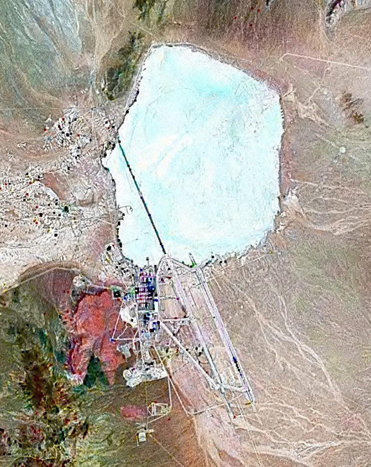
English: Landsat GeoCover 2000 pseudocolour imagery of Area 51 at Groom Lake, Nevada Test and Training Range, Nevada, USA
|
||||
| දිනය | circa 2000 | ||||
| මූලාශ්රය | NASA Landsat | ||||
| කර්තෘ | NASA | ||||
| අවසරය (මෙම ගොනුව නැවත භාවිතා කරමින්) |
|

ගොනු ඉතිහාසය
එම අවස්ථාවෙහිදී ගොනුව පැවැති ආකාරය නැරඹීමට දිනය/වේලාව මත ක්ලික් කරන්න.
| දිනය/වේලාව | කුඩා-රූපය | මාන | පරිශීලක | පරිකථනය | |
|---|---|---|---|---|---|
| වත්මන් | 12:42, 18 පෙබරවාරි 2010 | | 752 × 948 (383 කි.බ.) | Finlay McWalter | rv, that's not a landsat image; it looks very much like a copyright GeoEye/Google Earth image, which is inelligible for use on Commons. If you diagree, upload the image under another name, don't contaminate this one with false information |
| 11:05, 7 පෙබරවාරි 2010 |  | 456 × 617 (45 කි.බ.) | Vajotwo | Best quality | |
| 12:51, 16 ජූලි 2006 |  | 752 × 948 (383 කි.බ.) | Finlay McWalter | {{Information |Description=Landsat geocover 2000 pseudocolour imagery of Area 51 at Groom Lake, Nevada, USA |Source=NASA Landsat |Date=around 2000 |Author=NASA |Permission= {{PD-WorldWind}} |other_versions= }} Category:Area 51 |
ගොනු භාවිතය
පහත දැක්වෙන පිටුව විසින් මෙම ගොනුව භාවිතා කෙරෙයි:
ගෝලීය ගොනු භාවිතය
පහත දැක්වෙන අනෙකුත් විකියන් මගින් මෙම ගොනුව භාවිතා කරයි:
- ar.wikipedia.org හි භාවිතය
- az.wikipedia.org හි භාවිතය
- be.wikipedia.org හි භාවිතය
- bg.wikipedia.org හි භාවිතය
- bn.wikipedia.org හි භාවිතය
- cs.wikipedia.org හි භාවිතය
- cy.wikipedia.org හි භාවිතය
- el.wikipedia.org හි භාවිතය
- en.wikipedia.org හි භාවිතය
- es.wikipedia.org හි භාවිතය
- fi.wikipedia.org හි භාවිතය
- fr.wikipedia.org හි භාවිතය
- Zone 51
- Wikipédia:Le Bistro/14 février 2009
- Area 51 (jeu vidéo, 2005)
- Wikipédia:Wikimag/2019/28/Rapport de trafic
- Wikipédia:Wikimag/2019/29/Rapport de trafic
- Wikipédia:Wikimag/2019/29
- Wikipédia:Wikimag/2019/30/Rapport de trafic
- Wikipédia:Wikimag/2019/31/Rapport de trafic
- Wikipédia:Wikimag/2019/38
- Wikipédia:Wikimag/2019/39/Rapport de trafic
- gu.wikipedia.org හි භාවිතය
- he.wikipedia.org හි භාවිතය
- hi.wikipedia.org හි භාවිතය
- hr.wikipedia.org හි භාවිතය
- hu.wikipedia.org හි භාවිතය
- hy.wikipedia.org හි භාවිතය
- id.wikipedia.org හි භාවිතය
- it.wikipedia.org හි භාවිතය
- kk.wikipedia.org හි භාවිතය
- kn.wikipedia.org හි භාවිතය
- mk.wikipedia.org හි භාවිතය
- my.wikipedia.org හි භාවිතය
- pnb.wikipedia.org හි භාවිතය
- ro.wikipedia.org හි භාවිතය
- ru.wikipedia.org හි භාවිතය
- sh.wikipedia.org හි භාවිතය
- sk.wikipedia.org හි භාවිතය
මෙම ගොනුවේ තවත් ගෝලීය භාවිත බලන්න.