
ගොනුව:Exeter-20may44.jpg
මෙයට ඉහල විසර්ජනයක් ලබාගත නොහැක.
Exeter-20may44.jpg (600 × 555 පික්සල, ගොනු විශාලත්වය: 79 කි.බ., MIME ශෛලිය: image/jpeg)
සාරාංශය
| විස්තරය |
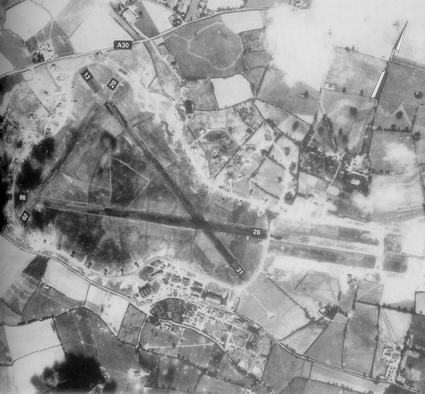
English: Exeter Airfield, England |
||||||
| දිනය | |||||||
| මූලාශ්රය | Freeman, Roger A., Airfields Of The Ninth, Then And Now, 1993 (where the annotations are from) | ||||||
| කර්තෘ | Royal Ordinance Survey. | ||||||
| අවසරය (මෙම ගොනුව නැවත භාවිතා කරමින්) |
|

ප්රකෘති පැටවුම් ලොගය
The original description page was here. All following user names refer to en.wikipedia.
- 2007-05-15 23:39 Bwmoll3 600×555×8 (81388 bytes) Exeter Airfield, England, 20 May 1944 Source: Royal Ordinance Survey. Crown Copyright expired 50 years after photograph taken in 1994. Annotations on photo from Freeman, Roger A., Airfields Of The Ninth, Then And Now, 1993
ගොනු ඉතිහාසය
එම අවස්ථාවෙහිදී ගොනුව පැවැති ආකාරය නැරඹීමට දිනය/වේලාව මත ක්ලික් කරන්න.
| දිනය/වේලාව | කුඩා-රූපය | මාන | පරිශීලක | පරිකථනය | |
|---|---|---|---|---|---|
| වත්මන් | 10:29, 21 මැයි 2008 | | 600 × 555 (79 කි.බ.) | Aps1 | {{Information |Description={{en|Exeter Airfield, England, 20 May 1944 Source: Royal Ordinance Survey. Crown Copyright expired 50 years after photograph taken in 1994. Annotations on photo from Freeman, Roger A., Airfields Of The Ninth, Then And Now, 1993 |
ගොනු භාවිතය
පහත දැක්වෙන පිටුව විසින් මෙම ගොනුව භාවිතා කෙරෙයි:
ගෝලීය ගොනු භාවිතය
පහත දැක්වෙන අනෙකුත් විකියන් මගින් මෙම ගොනුව භාවිතා කරයි:
- bg.wikipedia.org හි භාවිතය
- ca.wikipedia.org හි භාවිතය
- en.wikipedia.org හි භාවිතය
- ru.wikipedia.org හි භාවිතය
- uk.wikipedia.org හි භාවිතය
- vi.wikipedia.org හි භාවිතය